Pradeep Patil
Mulshi: Blessed with Abundant Nature
The western region of Pune city is home to the talukas of Bhor, Mulshi, Velha, and Maval, nestled amidst the rugged terrain of the Sahyadri mountain range. These talukas are not only known for their historical significance from the era of Chhatrapati Shivaji Maharaj but are also regarded as areas abundantly blessed by nature. Among them, Mulshi stands out as the closest to Pune city and is often referred to as the “Kashmir of Pune district” due to its breathtaking natural beauty.
Mulshi’s scenic landscape captivates urban dwellers from across the globe, making it a favored tourist destination. Towering mountains covered in lush green forests throughout the year, massive reservoirs like Temghar, Varasgaon, and Mulshi that supply water to Pune city and the eastern parts of the district, and pollution-free, ever-flowing rivers like Mula and Mutha enhance the region’s charm. Additionally, historic forts like Tung and Tikona, standing on the Maval-Mulshi border, provide a glimpse into Shivaji Maharaj’s legacy, further attracting history enthusiasts and nature lovers alike.
Mulshi is also renowned for its agricultural produce, supplying premium rice varieties such as Indrayani and Ambemohar, along with high-quality mangoes like Hapus (Alphonso) and Raywal to cities like Mumbai and Pune. Traveling along the Pune-Mahad highway, one encounters the ever-changing beauty of the Tamhini Ghat region—soaring cliffs on one side and deep valleys on the other.
During the monsoon, the region experiences heavy rainfall comparable to the Konkan, while in winter, the mountains are draped in thick fog. Even in peak summer, the vast water body of the Mulshi Dam provides a cooling effect. The picturesque Palase waterfall in this region sees a surge of visitors during the rainy season. Summer offers the delight of wild berries like karvanda, jamun, and wild apples.
Apart from large-scale residential projects, Mulshi is home to spiritual centers like Chinmay Vibhooti and Hadshi, agritourism initiatives, and the Maharashtra Tourism Development Corporation’s (MTDC) water tourism project at Malhar Machi. Traveling to the westernmost part of the taluka offers an elevated viewpoint, from where the Konkan region, shrouded in mist during the monsoon and winter, becomes clearly visible in summer.
To accommodate the growing number of tourists, several renowned business groups have established international-standard hotels in the region. Many city dwellers seeking a break from their hectic schedules visit Mulshi, especially on weekends, making it a popular getaway.
A Second Home for City Dwellers
The stress of city life, pollution, and traffic congestion have led many to seek weekend retreats. As a result, people are increasingly opting for rental homes or purchasing properties in Mulshi to escape urban chaos. This has spurred the development of several high-end residential projects by national and international real estate firms. Additionally, those desiring a closer connection with nature are purchasing farmland and building farmhouses based on their financial capacity. Consequently, land prices in the region have skyrocketed.
The 1980s saw the establishment of an international IT park in this taluka, followed by the rise of the MIDC (Maharashtra Industrial Development Corporation) in the Pirangut area, leading to a concentrated population in these regions. Large-scale land acquisitions in these areas have resulted in extensive construction, replacing once-thriving green hills with concrete jungles.
Despite urbanization, the government has recognized the need for environmental conservation. To protect Mulshi’s natural beauty, biodiversity, and ecological balance, the government has designated thousands of hectares of the Tamhini region as a Green Zone to ensure its preservation for future generations.
Mula River
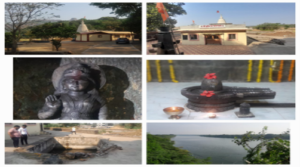
The historic Muleshwar Temple, situated at the source of the Mula River in the lap of the Sahyadris. The Mula River—a lifeline supplying water to the Ujjani Dam as well as Mulshi Taluka—originates at Devghar, a village known as the northwesternmost settlement of Mulshi Taluka. This village marks the boundary not only between the Mulshi and Maval talukas but also between the Pune and Raigad districts.
Although this village has recently gained global recognition due to Sahara City, many are still unaware that it is the place where the Mula River originates. However, the villagers and their ancestors have preserved the memory of this source.
Just as an ancient temple dedicated to Goddess Krishnai stands at the source of the Krishna River in Mahabaleshwar, a similar small temple and a *Gomukh* (cow-mouth spout) have long existed at this location. Adjacent to this source lies the old, historic Muleshwar temple; a new *Sabhamandap* (assembly hall) has also been constructed here in recent times as part of the temple’s renovation. Local villagers hold differing views regarding the exact source of the Mula River.
There is a belief that the natural water stream flowing down from the Barava of the Muleshwar temple in Deoghar village should be the source, while a perennial spring near the cremation ground, approximately four to five hundred meters away from the village, is said to be the true source of the Mula river. In both these places, local youth and villagers have taken the initiative and undertaken a clean-up work at both these source points as well as the work of making Barava at these places.
Rajendra Hundare and Vilas Hundare—local activists dedicated to the conservation of this source—reported that the number of visiting devotees is increasing day by day due to the publicity the site has recently received.
These two perennial streams eventually flow into the lake created at Ambavane village (the site of the current Sahara City). Further downstream, this watercourse is known as the Mula River.
After flowing for another 25 kilometers, this river meets the Nila River—which originates near Nive and Tamhini—close to Mulshi village. The Tata Company constructed the Mulshi Dam at the confluence of the Mula and Nila rivers approximately a century ago. This dam now supplies drinking water to numerous villages in Mulshi Taluka and provides water for agriculture to villages situated along the riverbanks. After pausing briefly in the Mulshi Dam reservoir and having traveled roughly 40 to 45 kilometers from its source, the Mula River assumes a fierce, turbulent form during the monsoon season at Shere, Ravade, and Paud.
As it flows further, the river assumes a vast expanse. After passing through the city of Pimpri-Chinchwad, it meets its ‘sister’—the Mutha River, which flows from Mulshi Taluka—in the Shivajinagar area. Together, they merge into the Ujani Dam via the Bhima River and eventually reach Pandharpur, where, as the Chandrabhaga, they surrender themselves at the feet of Lord Vitthal.
Devotees believe that, in a sense, the stream of water flowing from the *Gomukh* (cow-mouth spout) near the Muleshwar temple has emerged specifically to perform *Jal-Abhishek* (ritual water offering) upon Lord Vitthal of Karnataka and to purify the millions of devotees who bathe in it.
Photos:
1) The Muleshwar temple, built at the source of the Mula River in Devghar, Taluka Mulshi.
2) The *Shivling* inside the Muleshwar temple.
3) The perennial water spring at the source, located next to the Muleshwar temple.
4) Another water stream situated near the village of Muleshwar.
Transcription: Mr. Pradeep Patil
Compilation Assistance: Mr. Akash Marne, Mr. Sagar Shinde